


tendon

michelelfn
User
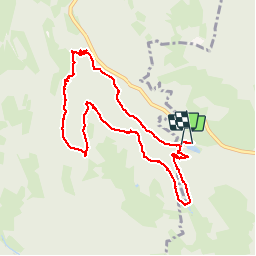

Length
9.1 km

Max alt
699 m

Uphill gradient
286 m
Km-Effort
12.9 km

Min alt
504 m

Downhill gradient
292 m
Boucle
Yes
Creation date :
2014-12-10 00:00:00.0
Updated on :
2014-12-10 00:00:00.0
3h01
Difficulty : Easy

FREE GPS app for hiking
 SityTrail
IGN / Geographical institutes
SityTrail Plus
The world is yours!
About
Trail Walking of 9.1 km to be discovered at Grand Est, Vosges, Le Tholy. This trail is proposed by michelelfn.
Description
tendon
Positioning
Country:
France
Region :
Grand Est
Department/Province :
Vosges
Municipality :
Le Tholy
Location:
Unknown
Start:(Dec)
Start:(UTM)
328630 ; 5329984 (32U) N.
Comments
Très belle rando entre bois et cascades.